The assessment of slope stability and the prediction of landslide evolution are difficult activities that require the identification of the variables involved and their careful and long-term monitoring.
Rainfalls are widely considered as the most important landslide triggering factor. They may control directly the landslide triggering or indirectly by means of fluctuation of groundwater levels.
Displacement can be obtained with different survey techniques.
Example of application to the Tessina landslide site
Here, we report the case of the Tessina landslide site (Belluno, Italy) for which displacement data were obtained from the analysis of image sequences and differentiated for different zones .
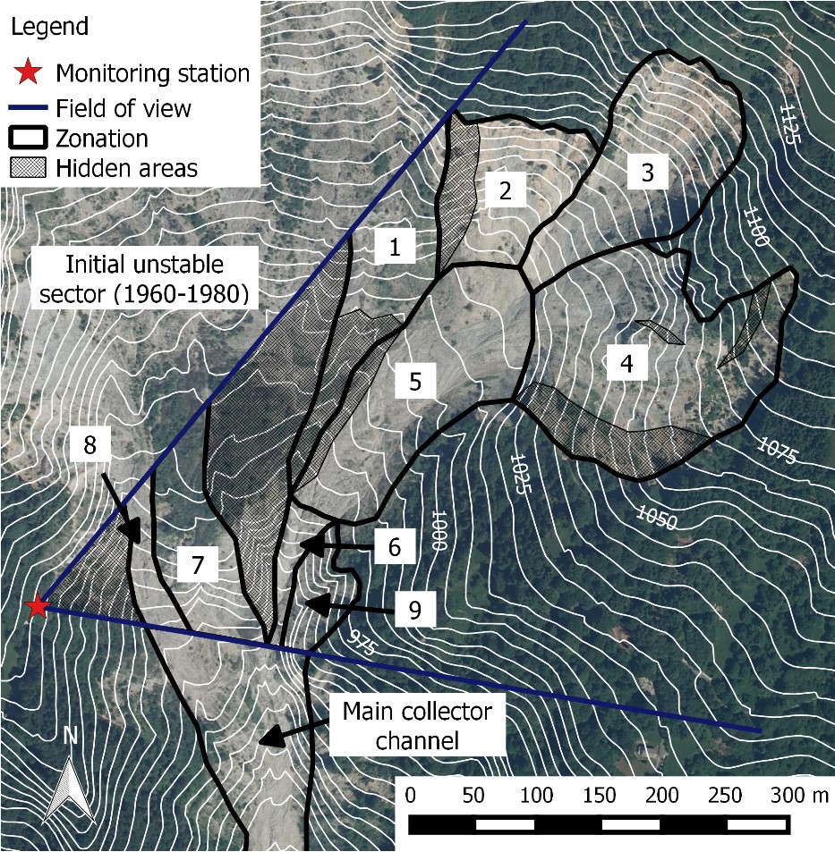
Geomorphological zonation of the source area of the Tessina landslide
From displacement data of the different portions of the source area, it is possible to measure the probability cascade between movement events.
Oriented graph of the binary logistic regression on the zones. The numerical values refer to the odds ratio (i.e., the relative probability of movement when the movement of another zone (or their synergic movement) was observed). Example of reading: the displacement of zone 5 is increased to 5.75 when zone 3 and 4 moves.
Also rainfalls are directly correlated to displacement.
Monthly cumulative rainfall and sum of displacement occurrences in each zone of the Tessina landslide.
From probabilistic analysis is possible to obtain many important information about the behaviour of the landslide. For example, for what concern the upper scarps (zone 1, 2, 3, 4), it was proved that the probability of movement is driven by combination of short rainfall duration, high maximum intensity and low mean intensity (i.e. scattered rainfalls) or the combination of long rainfall duration, high intensity and low maximum intensity (i.e., long and relatively uniform rainfall patterns). On the other hand, the persistency of movement depends more on the duration and intensity than on the maximum rainfall intensity; in other words, the total amount of rainfall is more important to the duration of movement than the peak rainfall.
Results of the logistic model for the zones 1, 2, 3, 4 of the Tessina landslide (upper scarps). The graph shows the displacement probability as a function of the rainfall intensity and rainfall duration.
Example of application to the Recoaro landslide site
A stereophtogrammetric technique was applied to assess the activity of the Recoaro landslide .
Results of the metric displacement field obtained by observations from three cameras pointed on the lower part of the landslide.
Example of application to the rocky pillars of Mt. Peron